Here are cue sheets and links to maps for many popular GEARs cycling club rides in the greater Eugene area.
The table below contains links to both cue sheets and maps for each ride. The “Ride No.” column is the link to each ride’s Cue Sheet. The Name column is a description of the destination and route. We’ve included Mileage, Grade (A-Easy (flat), B-Harder (rolling hills), C-Hard (hilly)), Map (the link to the Ride with GPS Map), Food (BF-Bring Food, FS-Food Store, FR-Restaurant), and Direction to profile each ride. The Map column contains links to custom Ride with GPS maps for each ride.
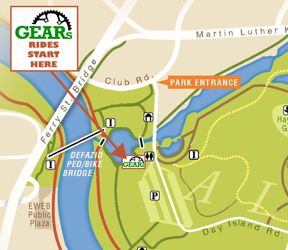
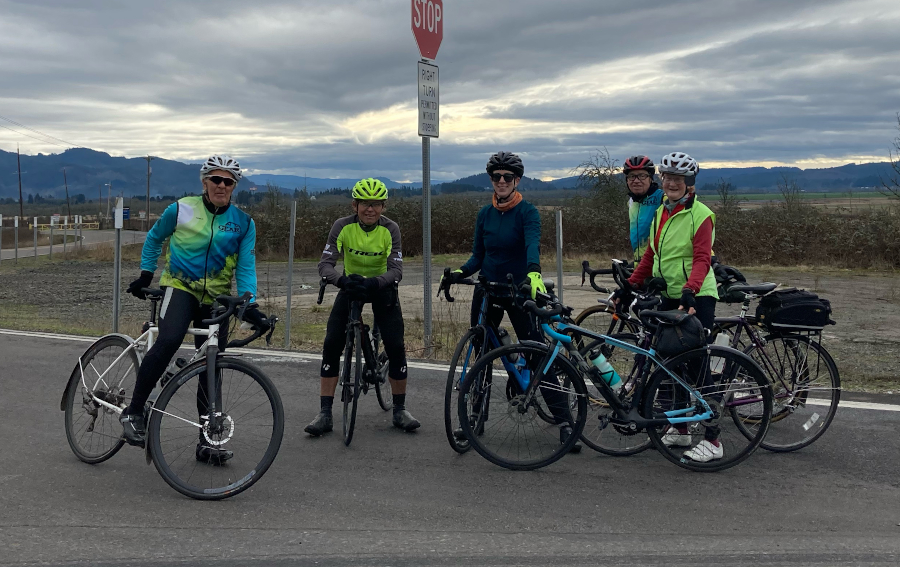
Most of the rides described here begin and end at Alton Baker Park, in Eugene. The general direction category reflects that location. The rides below are sorted by zones, roughly separated by HWY 99N in the north/south direction and HWY 126 in the east/west direction (click here to see the zone map.). While many rides cross the listed zones, most of the ride will be within its listed zone.
Many of the routes in the original local descriptions list were mapped by Rob Roy, an active and valued member of the club from 2002 until he passed in 2021. We are indebted to Rob for sharing his technical skills with us and making it much easier for members to navigate the routes in Lane County.
If you find the routes here beneficial consider supporting our efforts by joining GEARs. You can join on our membership page.
If you find errors or issues, please let us know and we will work to get them corrected (email: michael@eugenegears.org).
Zone 1: North / Northeast
| Ride No. | Ride Description | Milage | Grade | Gain | Map | Food | Dir. |
|---|---|---|---|---|---|---|---|
| 102a | Priceboro Drive | 44 | A | Map | FS | N | |
| 103a | Coburg Road to Bowers Rd | 39 | A | 389' | Map | FS | N |
| 103b | Coburg Rd to Herman Rd | 32 | A | Map | FS | N | |
| 103c | Coburg Bottom Loop – Coburg Rd | 27 | A | 320' | Map | FS | N |
| 103d | Herman Rd via Coburg Bottom Loop | 33 | A | 350' | Map | FS | N |
| 103e | Bowers Rd. Via Coburg Btm Loop | 39 | A | 380' | Map | FS | N |
| 104a | Harrisburg Long Way Around | 66 | A | Map | FS | N | |
| 104b | Harrisburg / Junction City Area | 47 | A | Map | FS | N | |
| 104c | Harrisburg via Coburg | 44 | A | 346' | Map | FS | N |
| 104d | Harrisburg via River Rd. | 46 | A | Map | FS | N | |
| 104e | Harrisburg via Diamond Hill Rd | 52 | A | Map | BF/FS | N | |
| 105a | Brownsville via Marcola/Brush Creek Road | 75 | C | Map | FS | E/NE | |
| 105b | Brownsville via Gap Rd, Rtn via Marcola | 77 | C | 2323' | Map | FS/FR | N/NE |
| 105c | Brownsvilla via Gap Rd Return Lake Creek/Rowland | 66 | B | Map | FS | N | |
| 105d | Brownsville via N Coburg Rd, Rowland, Love Cr, Run Brush Creek Rd | 80 | B | Map | FS | N | |
| 106a | Wendling Covered Bridge | 51 | B | Map | FS | E/NE | |
| 106b | Wendling Covered Bridge, CCW | 51 | B | Map | FS | E/NE | |
| 108a | Brownsville via Gap Rd | 70 | A | Map | FS | N/NE | |
| 108b | Brownsville staying mostly West of freeway | 77 | C | Map | BF/FS | N/NE | |
| 108c | Brownsville via Willamette Valley Scenic Bikeway | 65 | B | Map | BF/FS | N/NE | |
| 110a | Marcola | 38 | B | Map | FS | E/NE | |
| 111a | Walterville via Springfield | 42 | A | Map | FS | E | |
| 111b | Walterville and McKenzie View | 42 | B | Map | BF/FS | E | |
| 111c | Walterville – Out and Back | 35 | B | Map | FS | E | |
| 113a | McKenzie View Drive | 26 | B | 543' | Map | BF | E |
| 113b | McKenzie View via I-5 Path | 25 | B | 535' | Map | BF | E |
| 113c | McKenzie View & Sunderman via I-5 Path | 34 | B | Map | FS | E/NE | |
| 113d | McKenzie View/Coburg Bottom Loop | 36 | B | Map | FS | E/NE | |
| 114a | McKenzie View to Walterville | 42 | B | Map | FS | E | |
| 114b | McKenzie View and Sunderman | 35 | B | 781' | Map | FS | E/NE |
| 114c | McKenzie View – Sunderman – Walterville | 52 | B | Map | FS | E/NE | |
| 114d | McKenzie View and Sunderman, Reversed | 35 | B | Map | FS | NE | |
| 114e | McKenzie View, Sunderman, McKenzie View | 39 | B | Map | FS | NE | |
| 115a | I-5 Path, McKenzie View, Sunderman | 34 | B | 782' | Map | FS | NE |
| 115b | McKenzie View, McGowan Creek Rd | 43 | C | 1726' | Map | FS | N/NE |
| 116a | Walterville via Thurston Rd | 34 | B | Map | FS | E | |
| 116b | Walterville via Thurston Rd – Reversed | 36 | B | Map | FS | E | |
| 116c | Walterville via Thurston Rd to McKenzie View | 42 | B | Map | FS | E | |
| 117a | Upper Camp Creek Road | 37 | B | Map | BF | E | |
| 117b | Upper Camp Creek Rd via Mill Path, 42nd St | 38 | B | Map | BF | E | |
| 117c | Walterville via Camp Creek, Return Thurston Rd | 38 | B | 823' | Map | FS | E |
| 117d | Upper Camp Creek from Marcola Rd Albertson's | 27 | B | 815' | Map | BF | E |
| 118a | Deerhorn | 48 | B | Map | FS | E | |
| 118c | Deerhorn Dr from Lively Park | 35 | B | Map | FS | E | |
| 120a | Mohawk Store | 42 | B | Map | FS | N/NE | |
| 121a | Powerline Road | 42 | B | Map | FS | N | |
| 122a | McKenzie View to Deerhorn | 58 | B | Map | FS | E/NE | |
| 122b | McKenzie View, Sunderman, Deerhorn | 68 | B | Map | FS | E/NE | |
| 123b | Earnest Covered Bridge | 44 | B | Map | FS | E/NE | |
| 124a | Brownsville-Shedd | 79 | A | Map | FS | N/NE | |
| 125a | Clearwater Trail & Scenic Springfield | 24 | B | 536' | Map | BF | E |
| 125b | Clearwater Trail to McKenzie View | 29 | B | 680' | map | BF | E/NE |
| 125c | McKenzie View, Sunderman, Clearwater | 39 | B | Map | FS | N/NE | |
| 125d | Clearwater Trail, Sunderman, McKenzie View | 37 | B | 1019' | Map | FS | E/NE |
| 125e | Mill Race and Scenic Springfield, Short | 21 | A | Map | BF | E/NE | |
| 126a | Mill Race to Sunderman | 32 | B | Map | FS | E/NE | |
| 127a | Mt Tom via Coburg return N. Coburg Rd | 43 | B | Map | FS | N |
Zone 2: North / Northwest
| Ride No. | Ride Description | Milage | Grade | Gain | Food | Map | Dir. |
|---|---|---|---|---|---|---|---|
| 201a | Junction City via Love Lake Rd | 35 | A | FS | Map | N | |
| 201b | Junction City | 33 | A | FS | Map | N | |
| 201c | Junction City via Toftdahl Rd | 42 | A | FS | Map | N | |
| 201d | Junction City, Toftdahl, Alvadore, Fern Ridge | 53 | A | 459' | FS | Map | N/NW |
| 201e | Junction City via Toftdahl, Return Green Hill, Awbrey | 44 | A | 388' | FS | Map | N/NW |
| 202a | Junction City, Monroe, Coburg | 62 | B | BF/FS | Map | N | |
| 205a | Ingram Island Loop | 56 | A | FS/FR | Map | N | |
| 205b | Ingram Island Loop via Coburg | 66 | A | FS/FR | Map | N | |
| 207a | Franklin Firehouse | 40 | B | 585' | FS | Map | W/NW |
| 207b | Franklin Firehouse Reversed | 41 | B | FS | Map | W/NW | |
| 207c | Franklin Friehouse via NW Expressway | 36 | B | FS | Map | W/NW | |
| 207d | Franklin Firehouse via Clear Lake | 38 | B | FS | Map | W/NW | |
| 207e | Franklin Firehouse via Clear Lake Alt | 38 | B | FS | Map | W/NW | |
| 208a | Franklin, Cheshire | 45 | B | FS | Map | W/NW | |
| 208b | Franklin, Cheshire, Dorsey | 48 | B | FS | Map | W/NW | |
| 209a | Alvadore Road – Short | 30 | A | BF | Map | W/NW | |
| 209b | Alvadore Road via NW Expressway | 30 | A | BF | Map | W/NW | |
| 209c | Alvadore via Meadowview | 35 | A | FS/FR | Map | N/NW | |
| 209d | Alvadore via Milliron Rd | 36 | A | 410' | FS/FR | Map | N/NW |
| 209e | Alvadore Short - Out & Back | 30 | A | FS | Map | W | |
| 211a | Lawrence Road and Short Butler Road | 41 | C | 1050' | FS/BF | Map | W |
| 211c | Lawrence Road and Butler Two Ways | 57 | C | FS/BF | Map | W | |
| 212a | Cheshire | 53 | B | FS/BF | Map | W | |
| 212b | Hills around Cheshire | 51 | B | FS/BF | Map | W | |
| 212d | Cheshire Hills, Cox Butte | 58 | C | 1429' | FS | Map | W/NW |
| 214a | Sovern Lane | 38 | A | 378' | BF | Map | N |
| 215a | Meadowview Road | 34 | A | BF | Map | N | |
| 215b | Alvadore via Fern Ridge Path | 34 | A | BF | Map | N | |
| 216a | Cox Butte Road | 58 | B | BF/FS | Map | N | |
| 221a | Turnbow, Cox Butte and other climbs | 58 | B | BF/FS | Map | W/NW | |
| 223a | Bell Fountain Road | 70 | C | FS | Map | N/NW | |
| 224a | West Hills: Butler Road, Sheffler Road, etc. | 65 | C | BF | Map | W/NW | |
| 226a | Junction City, Dorsey, Prairie Rd | 41 | A | FS | Map | N | |
| 226b | Junction City, Dorsey, Reversed | 41 | A | 354' | FS | Map | N |
| 227b | Applegate, Return Alvadore, Fern Ridge | 46 | B | 599' | FS | Map | N |
| 227c | Applegate Trail Counter Clockwise | 49 | B | FS | Map | N | |
| 227d | River Rd, Oakley, Cox Butte | 49 | B | FS | Map | N/NW | |
| 228a | E/W Beacon Road | 21 | A | BF | Map | N | |
| 229a | Irving Rd to Fir Butte | 25 | A | BF | Map | N/NW | |
| 230a | Goldson, Hall & Smyth Rds. | 58 | C | BF | Map | NW/N | |
| 235a | Grimes via Horton | 76 | C | BF/FS | Map | NW | |
| 235b | Grimes via Horton/Clearlake from NEHS | 71 | C | BF/FS | Map | NW | |
| 240a | Looping River Loop, Santa Clara | 17 | A | BF | Map | NW | |
| 241a | Wetlands After Work | 15 | A | 118' | BF | Map | W |
| 245a | Kirk, Butler, Vaughn | 59 | C | 2349' | FS | Map | W |
Zone 3: South / Southwest
| Ride No. | Ride Description | Milage | Grade | Gain | Map | Food | Dir |
|---|---|---|---|---|---|---|---|
| 300a | Crow (town) | 40 | C | 1179' | Map | FS | W/SW |
| 300b | Town of Crow -Alt | 38 | C | Map | FS | SW | |
| 301a | Central via Crow (town) | 38 | C | Map | BF | W/SW | |
| 301b | Crow via Central | 38 | C | Map | FS | W/SW | |
| 301c | bRamble Crow Loop | 43 | C | Map | FS | W/SW | |
| 301d | Crow via Central, Reversed | 39 | C | Map | BF | W/SW | |
| 302a | Veneta via Petzold, Central | 47 | B | 1293' | Map | FR/FS | W |
| 302b | Veneta via Fleck Rd | 44 | B | Map | FR/FS | W | |
| 302c | Veneta via Central, Bolton Hill | 50 | B | Map | FR/FS | W | |
| 302d | Veneta via Fern Ridge Path, Petzold | 45 | B | Map | FR/FS | W | |
| 302e | Veneta via Bolton Hill Rd | 50 | C | 1695' | Map | FS | W |
| 302f | Veneta via Bolton, Return Deming, Clear Lake | 50 | C | Map | FS | SW | |
| 302g | Veneta via Petzold, Central, Deming | 47 | C | Map | FS | SW | |
| 303a | Butler - Veneta Loop | 59 | C | Map | FS | NW | |
| 304a | NOTI – Poodle Creek | 62 | C | Map | FS | W | |
| 306a | Gimpl Hill via Pine Grove | 25 | C | Map | BF | W/SW | |
| 306b | Gimple Hill Road via Erickson-Crow Roads | 25 | C | Map | BF | W/SW | |
| 306c | Gimple Hill Road via Crow Road - Alt | 30 | C | Map | BF | W/SW | |
| 306d | Gimple Hill Road via Fern Ridge Path, Pine Grove | 25 | C | Map | BF | W/SW | |
| 307a | Fox Hollow/Lorane Hwy | 30 | C | Map | BF | SW/W | |
| 307b | Fox Hollow/Down McBeth/Lorane Hwy | 22 | C | Map | BF | SW | |
| 307c | McBeth Rd – Lorane Hwy – Bailey Hill Rd | 30 | C | Map | BF | SW | |
| 307d | Fox Hollow, Lorane Hwy, Pine Grove Rd | 39 | C | Map | BF | SW | |
| 307e | Fox Hollow, Briggs Hill, Pine Grove Rd | 43 | C | Map | BF | SW | |
| 307f | Fox Hollow, Lorane Hwy, Gimpl Rd | 36 | C | Map | BF | SW | |
| 307g | Fox Hollow, McBeth, Gimpl | 32 | C | 1963' | Map | BF | S |
| 307h | Fox Hollow to Dillard | 28 | C | 2183' | Map | BF | S |
| 308b | Wolf Creek (counter clockwise) | 72 | C | Map | FS | W/SW | |
| 308e | Wolf Creek via Lorane (Town) | 71 | C | Map | FS | W/SW | |
| 308f | Fox Hollow, Welders Hill, Bailey Hill Rd | 30 | C | Map | BF | S/SW | |
| 312a | McBeth Road, Fox Hollow Road, Lorane, Bailey Hill | 31 | C | Map | BF | SW | |
| 313a | McBeth, Fox Hollow | 23 | C | 1580' | Map | BF | SW |
| 314a | Hamm Road via River Drive and Howe Lane | 63 | C | Map | BF | SE | |
| 314b | Hamm Road | 46 | C | Map | FS | SW | |
| 314c | Hamm Road via Lorane Hwy | 48 | C | Map | FS | SW | |
| 314d | Hamm Road via Fox Hollow | 49 | C | Map | FS | SW | |
| 315a | Creswell via Dillard | 33 | C | Map | FR/FS | S/SE | |
| 317a | Pine Grove Road | 28 | C | Map | BF | SW | |
| 317b | Crow Road via Erickson Road | 29 | B | Map | BF | SW | |
| 318a | Briggs Hill Rd to Doane Rd | 37 | C | 1419' | Map | BF | SW |
| 318b | Doane Rd to Briggs Rd | 41 | C | Map | BF | SW | |
| 318c | Fox Hollow, Briggs, Gimpl | 40 | C | Map | BF | SW | |
| 318d | Swing Log Bridge via Lorane Hwy | 42 | C | 2035' | Map | FS | SW |
| 319a | Lorane Hwy to Crow Rd | 30 | C | 806' | Map | BF | SW |
| 319b | Lorane Hwy to Petzold, Out & Back | 35 | B | 984' | Map | BF | W |
| 322a | Cottage Grove via Lorane | 62 | C | 2825' | Map | FS | S/SW |
| 322b | Cottage Grove | 74 | C | Map | FS | S | |
| 322d | Cottage Grove via Dillard Rd | 63 | C | Map | FS | S | |
| 324a | Bailey Hill Rd, Lorane Hwy, Fox Hollow | 30 | C | 2021 | Map | BF | SW |
| 325a | Bailey Hill / Lorane Hwy / McBeth Rd | 27 | C | Map | BF | SW | |
| 326a | Lorane (town) via Fox Hollow Rd | 49 | C | Map | BF | SW | |
| 328a | Noti – Fern Ridge Loop | 50 | C | Map | BF | SW | |
| 329a | 6 Hills and a Funeral | 61 | D | Map | BF | SW | |
| 330a | 4 Hill climb-R-U Ready? | 37 | C | Map | BF | SW | |
| 333a | Four Hills #1 | 41 | C | Map | BF | SW | |
| 334a | Four Hills #2 | 35 | C | Map | BF | SW | |
| 335a | Two Hills – Bike Path | 36 | C | Map | BF | SW | |
| 337a | Veneta via Vaughn, Knight & Warthen | 61 | C | Map | FS | SW | |
| 340a | Blanton, Lorane, Willamette, Fox Hollow, Lorane Hwy, McBeth | 41 | C | Map | BF | S |
Zone 4: South / Southeast
| Ride No. | Ride Description | Milage | Grade | Gain | Map | Food | Dir. |
|---|---|---|---|---|---|---|---|
| 401a | Pleasant Hill via Bear Creek | 45 | C | Map | FS | SE | |
| 401b | Pleasant Hill - Shorter | 26 | C | Map | FR | SE | |
| 401c | Pleasant Hill - Short | 28 | C | Map | FR | SE | |
| 401d | Pleasant Hill including Wheeler Rd | 58 | C | Map | FR | SE | |
| 401e | Pleasant Hill via Bear Creek - Alt | 45 | C | Map | FS | SE | |
| 401f | Pleasant Hill to Jasper | 41 | C | Map | FS | SE/E | |
| 402a | Lowell | 52 | C | Map | FS | SE | |
| 403a | Jasper via Weyerhauser | 35 | B | Map | FS/BF | SE | |
| 403b | Jasper via Pleasant Hill | 31 | B | Map | FS | SE | |
| 403c | Pleasant Hill via Brabham, return Clearwater, Mill Path | 32 | B | Map | FS | SE/E | |
| 403d | Jasper via 30th Ave, P. Hill | 42 | B | Map | FS | SE | |
| 403e | Jasper via Pleasant Hill, Reversed | 34 | C | Map | FS | E/SE | |
| 404a | Pleasant Hill to Bear Creek | 45 | B | Map | FS | SE | |
| 404b | Dillard, Bear Creek Rd, Jasper | 43 | C | Map | FS | SE | |
| 404c | Dillard to Brabham, Weyerhauser, Clearwater Trail | 35 | C | Map | FS | SE | |
| 405a | Bear Creek, P Hill, Clearwater | 46 | B | Map | FS | SE | |
| 405b | Pleasant Hill to Clearwater Trail | 40 | B | Map | FS | SE | |
| 406a | Weyerhaeuser Rd to Pleasant Hill, Out & Back | 35 | B | 1022' | Map | FS | E/SE |
| 406b | Weyerhaeuser Rd to Pleasant Hill, Out & Back, Garry's Alt | 34 | B | 968' | Map | FS | E/SE |
| 406c | Pleasant Hill via Weyerhaeuser, Alt 2 | 36 | B | 1231' | Map | FS | E/SE |
| 406d | Pleasant Hill via Weyerhaeuser, Alt 3 | 39 | B | 1308' | Map | FS | E/SE |
| 409b | Winberry Creek Park on Fall Creek Reservoir | 58 | B | Map | BF/FS | SE | |
| 410a | Dillard Road to Bear Creek | 37 | C | Map | BF | S/SE | |
| 410b | Over the Hump, Around the Dump – Dillard Road/Cloverdale | 32 | C | Map | BF | S/SE | |
| 410c | Over the Hump, Around the Dump – Dillard Access Road | 22 | C | Map | BF | S/SE | |
| 411a | Dillard Rd, Creswell, P. Hill, Clearwater | 47 | C | Map | FS | S/SE | |
| 412a | River Drive and Howe Lane | 41 | A | 682' | Map | FS/FR | S/SE |
| 412b | Howe Ln via Dillard Rd | 41 | C | Map | FS/FR | S/SE | |
| 412c | Howe Ln via Dillard Rd, Butte Rd | 37 | C | Map | FS/FR | S/SE | |
| 412d | Howe Ln to Butte Rd, Creswell Bakery | 37 | B | Map | FR/FS | S/SE | |
| 412e | Seavy Loop, River Dr, Howe Ln, Seavy Loop | 40 | B | Map | FR/FS | SE/S | |
| 415a | Seavy Loop, Dillard Rd | 21 | C | 884' | Map | BF | SE |
| 416a | Rattle Snake Butte | 53 | C | Map | FS | SE | |
| 416b | Rattle Snake Butte via Dexter | 59 | C | Map | FS | SE | |
| 416c | Rattle Snake Butte via Wheeler Rd | 51 | C | Map | FS | SE | |
| 417a | Dale Kuni | 34 | A | 574' | Map | FS/BF | SE |
| 417b | Cloverdale, Cresswell Bakery | 35 | B | 615' | Map | FS/FR | SE |
Community / Beginner Rides
| Ride # | Ride Description | Miles | Grade | Map | Food | Dir |
|---|---|---|---|---|---|---|
| 500a | Community Loop A | 5 | A | Map | BF | NE |
| 500b | Community Loop B | 10 | A | Map | BF | NE |
| 500c | Community Loop C | 15 | A | Map | BF | NE |
| 500d | Community Loop D | 21 | A | Map | BF | NE |
| 500e | Community Loop E | 21 | A | Map | BF | N |
| 500f | Community Loop F | 31 | A | Map | BF | N |
| 510a | River Loop #1 / Santa Clara | 17 | A | Map | BF | N |
| 550a | Mill Race Loop | 17 | A | Map | BF | E |
Special / Event Rides
| Ride No. | Ride Description | Milage | Grade | Gain | Map | Food | Dir. |
|---|---|---|---|---|---|---|---|
| 600a | Polar Bear Ride | 42 | C | Map | BF | N | |
| 601a | Daffodil Ride – from Junction City | 19 | B | 385' | Map | BF/FS | N/NW |
| 601b | Daffodil Ride – from North Eugene High | 45 | B | 526' | Map | BR/FS | N/NW |
| 601c | Daffodil Ride from Alton Baker Park | 54 | B | 728' | Map | BF/FS | N/NW |
| 601d | Daffodil Ride from NE High, Reversed | 44 | B | Map | FS | N/NW | |
| 602a | Harrisburg – 4th of July Parade | 46 | A | Map | BF/FS | N | |
| 602b | 4th of July Ride - Alternate | 49 | A | Map | FS/FR | N | |
| 604a | bRamble Orchard Point 39 Miler Classic | 39 | A | Map | FS | N/NW | |
| 604b | Poodle Creek Metric Century Classic | 62 | C | 2269' | Map | FS | W/SW |
| 604c | Wolf Creek Century Classic | 100 | C | Map | FS | W/SW | |
| 605a | 2019 bRamble Camas Country Loop | 39 | A | Map | FR | N/NW | |
| 605b | 2019 bRamble Veneta Clear Lake Metric | 65 | C | Map | FS | W/SW | |
| 605c | 2019 bRamble North Winery Tour | 83 | C | Map | FS | W/SW | |
| 605d | 2019 bRamble Wolf Creek Century | 103 | C | Map | FS | W/SW | |
| 605e | 2019 bRamble Epic | 117 | C | Map | FS | W/SW | |
| 606a | 2021 bRamble Crow Loop | 39 | C | Map | FS | W/SW | |
| 606b | 2021 bRamble Metric | 62 | C | Map | FS | W/SW | |
| 606c | 2021 bRamble Century | 101 | C | Map | FS | W | |
| 607b | 2021 bRamble Metric from ABP | 65 | C | Map | FS | W/SW |
|
| 607c | 2021 bRamble Century from ABP | 104 | C | Map | FS | W | |
| 610a | Alton Baker Park to Swartz Campground (out & back) | 65 | A | Map | FS | S | |
| 610b | Alton Baker Park to Swartz Campground (Long) | 43 | C | Map | FS | S | |
| 615a | Cinnamon Roll Ride - Short | 30 | B | 809' | Map | FR | WSW |
| 615b | Cinnamon Roll Ride - Long | 35 | B | 983' | Map | FR | WSW |
Gravel and Mixed Surface Rides
| Ride No. | Ride Description | Milage | Grade | Map | Food | Dir. | |
|---|---|---|---|---|---|---|---|
| 700a | Hills Creek Reservoir | 22 Miles | B | Map | BF | S | |
| 701a | Oakridge Gravel Ride | 33 Miles | D | Map | BF | NE | |
| 701b | Sasquatch Duro Little SQUATCH 2022 | 26 Miles | C | Map | BF | E/NE | |
| 702a | West Boundary Rd | 35 Miles | C | 1975' | Map | BF | E/NE |
| 702b | Boundary Rd from Lowell HS | 48 Miles | C | 2528' | Map | BF | E |
| 705a | Fall Creek Reservoir Mixed Surface from Jasper Park | 39 Miles | C | 1509' | Map | BF | E |
| 710a | Hall Rd to Butler, Mixed Surface | 62 Miles | C | Map | FS | NW | |
| 710b | High Pass, return via Hall (Mixed Surface) | 60 Miles | C | Map | FS | NW | |
| 710c | Hall, Fisk, and Butler from NEHS | 61 Miles | D | Map | BF | W | |
| 710d | Hall to Butler (mixed surface) from NEHS | 54 Miles | C | Map | BF | W/NW | |
| 701e | High Pass via Junction City, Rtn via Hall Rd. | 60 Miles | C | Map | BF | NW | |
| 711a | Grimes via High Pass, return via Milliron | 71 Miles | D | Map | FS | NW | |
| 720a | Wolf Creek Gravel | 19 Miles | C | Map | BF | WSW | |
| 721a | Vaughn, Siuslaw, Battle Creek from Alton Baker | 81 Miles | D | Map | BF/FS | W/SW | |
| 721b | Vaughn, Siuslaw, Battle Creek from Crow | 45 Miles | D | Map | BF | W/SW | |
| 730a | Monroe Mixed Surfaces | 21 Miles | C | Map | BF | W | |
| 730b | Monroe Mixed Surfaces | 25 Miles | C | Map | BF | W/NW | |
| 730c | Monroe via Wildlife Refuge | 37 Miles | C | Map | BF | W | |
| 731a | Monroe to Alsea Falls, mixed surface | 39 Miles | C | Map | BF | W/NW | |
| 731b | Monroe to Alsea Falls, mixed surface | 40 Miles | D | Map | BF | W | |
| 740a | Mary's Peak from Philomath (mixed surface) | 37 Miles | D | Map | BF | W | |
| 745a | Wolf Creek, H Line Long Loop | 38 Miles | D | Map | BF | S/SW | |
| 750a | Vaughn, C Mainline and Battle Creek Loop | 37 Miles | C | 2663' | Map | BF | W |
| 750b | Vaughn, C Mainline, and Battle Creek Loop Alt | 41 Miles | C | 3724' | Map | BF | W |
| 755a | Backroads of Harlan | 30 Miles | C | Map | BF | E | |
| 760a | Coburg Hills Loop from Mohawk | 33 Miles | D | Map | BF | N/NE | |
| 765a | Honeyman | 54 Miles | D | 5144' | Map | BF | E |
Remote Start Rides
| Ride No. | Ride Description | Milage | Grade | Map | Food | Dir | |
|---|---|---|---|---|---|---|---|
| 900a | Aufderheide Scenic Highway | 62 | C | Map | BF | E | |
| 901a | Veneta Loop | 28 | B | Map | FS | W | |
| 902a | Doane Hill – Briggs Hill Loop | 21 | C | Map | BF | W/SW | |
| 903a | Crow – Bolton Hill – Veneta | 31 | B | Map | FS | W | |
| 904a | Crow – Noti – Veneta Loop | 40 | B | Map | FS | W/NW | |
| 905a | Brownsville & Sodaville | 94 | C | Map | FS | N/NE | |
| 906a | Lorane General Store from Twin Oaks Elem | 29 | C | Map | FS | SW | |
| 907a | Roads Around Veneta | 35 | B | Map | FS | N/NW | |
| 908a | Wolf Creek from Twin Oaks Elementary | 54 | C | Map | FS | SW | |
| 908b | Wolf Creek (CCW) from Twin Oaks Elementary | ?? | C | N/A | FS | SW | |
| 908c | Wolf Creek from Twin Oaks | 54 | C | 3307' | Map | FS | S/SW |
| 909a | Spirit and Wildwood Falls via Cottage Grove | 52 | C | Map | BF | E | |
| 910a | Row River Trail to Cedar Creek Campground | 45 | B | 1721' | Map | BF | E |
| 910b | Row River Trail and climb up Brice Creek Rd | 69 | C | Map | BF | E | |
| 910c | Row River Trail to Wildwood Falls | 32 | B | 1051' | Map | BF | SE |
| 910d | Row River Trail to Wildwood Falls - Alt | 36 | B | 1233' | Map | BF | SE |
| 911a | Cottage Grove Two Lake Loop | 45 | B | Map | FS | E | |
| 920a | Mary's Peak & Alsea | 70 | D | Map | BF | NNW | |
| 925a | Old Stagecoach Rd | 30 | B | 1486' | Map | BF | W |
| 926a | Whitaker, Roman Nose, Baldy, Kentucky Creek | 33 | D | 4456' | Map | BF | S/SE |
| 930a | Newport and Siletz | 70 | C | Map | FS | NNE | |
| 940a | Shotgun Loop from Mohawk | 54 | D | Map | BF | N |